
ABSTRACT
It was in the Cancun Adaptation Framework of the United Nations Forum of Climatic Change that the National Adaptation Plan was established. This plan enables the parties to formulate and implement national adaptation plans for identifying medium and long term adaptation needs. It also directs to take into consideration the vulnerable groups, communities and ecosystems. The important principle to be noted is that such approaches should be guided by the best available sciences and institutions seen as appropriate. In Kerala, when we think of the development patterns associated with the infrastructure development and the land use imbued in it demands serious consideration to climatic change adaptation. This should be constructive and innovative contributions to the future of Kerala’s civil life so as to build a civilization pattern. For this, a thorough study of the land structure is to be done.
INTRODUCTION
If we go through the history of Kerala, the state has experienced severe floods which have led to the existing situations. It was in the 1341 floods that the then International trade Centre and port Muziris were washed out. In the last century, Kerala witnessed two major floods which seriously affected the social structure and infrastructure of Kerala. A look into the history of floods in Kerala, it is notable that the floods have diverted the course of social and infrastructure courses of Kerala society and that no serious measures have been taken to overcome such calamities. The floods of 2018 and 2019 explicitly confirm this fact.
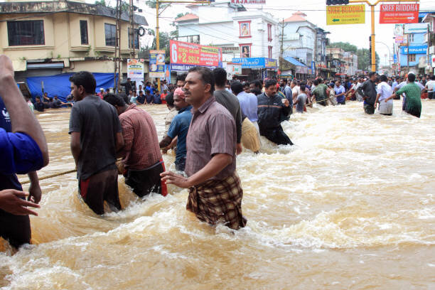
Upon careful analysis of the crisis caused by the floods in the years 2018 and 2019, it is observed that the flood situation and the devastations that ensued were mostly human-made. The aggravation of the floodwaters was due to the non-intervention of authorities by the timely action of opening up dams. It resulted in pushing more than half of the water pumped into the civil terrain which formed the majority share of the flood water content. The real estate boom and the change in the pattern of the land have also boosted the flood situation. This paper will look into the factors that played a part in aggravating the flood situations and suggest certain steps that could be taken to effectively deal with such situations in the future.
LAND STRUCTURE AND HABITAT PATTERNS: TRADITIONS AND DISTURBANCES
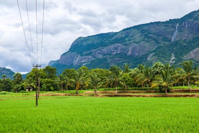
It is known that geographically Kerala was divided into three distinct regions – eastern highlands, central midlands, coastal plains, each with its own habitat patterns. Before migration from the midlands and from the south to the high ranges, the Western Ghats were comparatively free from large scale mining and buildings and the ones that were already in these areas were built in a way that was according to nature and ecology. Purayidam, thodi, vayal, thodu and kayal (housing plots, plantations, paddy fields, water channels and backwaters) consisted the habitat patterns. Thus, the land structures had ups and downs which conveniently tapped the water in the area where the rains were shed. Traditionally there were effective methods for the conservation and preservation of water and traditional water conservation structures like ponds, reservoirs helped in effective conservation and management of water resources. The groves and the agrarian tracts also acted as water reservoirs. But these patterns were disturbed thoroughly and now Kerala is very backwards when it comes to the effective management of the water resources.
Some instances of water conservation and management are to be closely watched to understand the scientific nature of water conservation techniques. Irrigation system in Kurumali region which drew the water from low-Level River to upper lands facilitated the upper lands as a repository of water for the non-rainy seasons. Similarly, through a series of water channels and ponds, the water was preserved and the flood situation was eliminated during the rainy days and water preserved in Kollangod Region(( http://www.kerenvis.nic.in/Database/Irrigation_Schemes_2246.aspx )).
REAL ESTATE BOOM AND ITS CONSEQUENCES
The real estate boom which gained momentum towards the end of the 20th century has greatly disturbed and destroyed the traditional waterways and preservation techniques. Paddy fields were converted into housing plots which caused a lot of serious problems. Flood plains, traditional water reservoirs, waterways etc were filled and converted into housing plots. The river lands were also encroached and this obstructed the free flow of rivers.
Upon consideration of the construction patterns of the houses, it can be observed that the construction patterns were different in different regions and the materials used for the constructions were generally procured from the local areas.
IMPACT OF INFRASTRUCTURE DEVELOPMENT
Per capita land is very low in Kerala. Development paradigm which professes and proliferates the big industries, property development and infrastructure developments- like the development of roads, bridges, flyovers etc. ousted out a large number of population from their traditional habitats. As a part of the programme, a large number of buildings were demolished. Majority of the materials of the destroyed buildings had no reusability.
The vehicle boom which took place at the end of the 20th century in Kerala is the reason for the intensive infrastructure development. The lands were taken over for infrastructure developments, which added to the already existing pressures on the land. The people who were being ousted from their traditional habitats were forced to search for lands for housings and settle in the impact areas of quarries, flood plains etc. These people became vulnerable to disasters. This is a representation of the sad reality that such marginalized classes face in the state and this lays importance on the need for new building technologies which can withstand the floods and the earthquakes.
There were certain attempts made in Kerala whereby materials like bamboo, mud, coconut shell etc. were used to build houses, the same would serve as alternatives to the current building patterns which is harmful to the ecology and the environment.
CONCLUSION
Kerala was devastated by severe floods. It was the worst flooding in Kerala in nearly a century. The floods had different impacts on different regions, whereby the main problem faced by the people of eastern highland was landslides and the people of central midlands and coastal plains were washed out due to flooding. Therefore, it is important to note that a common plan cannot be adopted to deal with the situations that prevail in the different regions of Kerala.
In the year 2011, Madhav Gadgil submitted a report ((Western Ghats Ecology Expert Panel – Wikipedia )) which found that the recent developmental plans were impacting the sustainability of Westen Ghats hill chains. Developmental plans must take into consideration
the differences that prevail in these regions and only the plans that are made in accordance with the traditional land structure can stand the test of time.
The paper has focused on the following themes:
- The patterns followed in the traditional habitat and the containment of the issues of water management and water conservation
- The use of land and materials for building houses and keeping a check on the excessive use of natural resources
- The alternative designs in both the above domains
It is argued that the current pattern of development and the development paradigm has to be reassessed thoroughly. It also argues that the development patterns and associated engineering should consider the traditional habitat structures and water management and preservations latent in those.
Bibliography
Books:
Achutha Menon C, Cochin State Manual, State Press, Ernakulam; 1911.
Aiyya Nagam, Travancore State Manual, State Press, Thiruvananthapuram, 1906
Cherian P J (ed.); Cultural Formation of Kerala; Thiruvananthapuram, Kerala Gazetteers Department; 1999.
Logan William, Malabar, State Press, Madras, 1989.
Varrier, Raghava, Madhyakaala Keralam, Thiruvananthapuram, Chintha; 1998.
Magazines:
Frontline, September 14, 2018.